Maps & Overlays
AirNav Radarbox is committed to giving users the freedom to customize their flight views. One of the ways we do this is by letting users choose from various categories of map styles. In addition to this, users can also augment their maps with overlays such as Routes & Tracks, ATC boundaries, Flight Labels, and more. Read on to learn how you can leverage all this and more to tailor and enhance your maps for the best flight tracking experience.
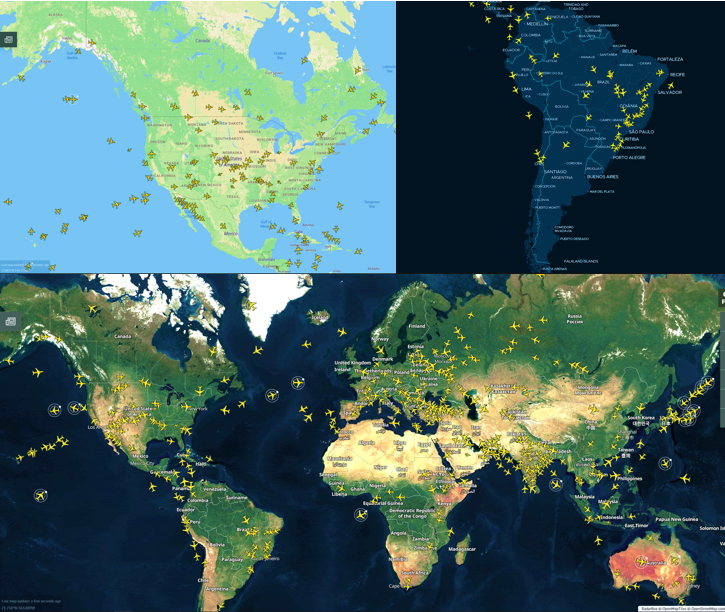
Image Above: Radarbox's Terrain, Dark & Satellite Maps with flights overlayed
1. 7 Different Maps
Each of our 7 map styles offers users a unique and intuitive visual experience to better augment their tracking experience. We've briefly explained each of the 7 maps below.

Image Above: The 7 Maps offered on Radarbox.com
- Satellite – This map style displays a map with satellite imagery. Satellite-style maps are ideal for those who prefer a geographic overview of the earth with flights overlayed in a contrasting manner.
- Terrain– Terrain maps are a style of maps that present elevation features like contour lines. Contours make it possible to show the height and shape of mountains and the steepness of slopes.
- Flat – This map style displays a colored representation of the world map with detailed geographic features, names of cities & countries, road and highway routes etc. However, these maps lack elevation information.
- Dark - Dark maps overlay lighter yellow-colored aircraft on a dark blue map. Landmasses are shown in a light shade of blue, whereas water bodies are shown in a darker shade of blue.
- Sky Vector Lo – Especially useful for flight crews, this map displays navigational waypoints and routes for low altitude flights.
- Sky Vector Hi - These maps display navigational waypoints and routes for high-altitude flights.
- Sky Vector VFR – The sky vector aeronautical chart is an excellent navigational reference for pilots and crews to use during flight planning and operations.
2. Overlays
Overlays give users additional tracking information by overlaying features on the map layout. In this blog, we will focus on the various map overlays and discuss ways to customize a unique view on RadarBox.
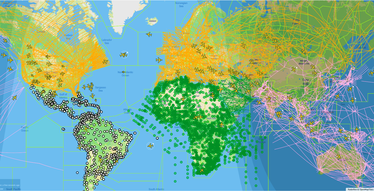
Image Above: Day/Night Layer, Global FIR's, NavAids in South America, Waypoints in Africa & Routes for Asia, Europe & America
- Day/Night Layer – Enabling this layer adds a shadow on the map, displaying if it is day or night in different parts of the world.
- FIR/ATC Boundaries – This feature overlays worldwide flight information region & ATC Boundaries on the map. Users can either hover over the ATC boundary or click the highlighted boundary to view more FIR / ATC zone details.
- NAVAIDS – This feature displays navigational aids, which are essentially, radio beacons that help pilots navigate while flying. Users can turn them on for specific geographic areas to see where navaid are present. Radarbox currently displays NavAids over Europe, Asia, Africa, the Middle East, North & South America, and over the Pacific & Atlantic oceans.
- Waypoints – Waypoints are represented as small pink circles on the Radarbox map and just like NavAids you can turn them on for specific geographic areas. Radarbox currently displays Waypoints over Europe, Asia, Africa, the Middle East, North & South America, and over the Pacific & Atlantic oceans.
- Routes – These “highways in the sky” show the various fixed tracks & routes that flights fly on. Each geographic area has its own color-coded routes for clear distinctions between continents. Radarbox currently displays Routes over Europe, Asia, Africa, the Middle East, North & South America, and over the Pacific & Atlantic oceans.
3. Labels & Units

Image Above: Toggles and options for map overlays
- Aircraft Labels – This option provides the possibility for customization in two ways. When turned on, The Always Show toggle allows users to display flight labels on screen only if there are less than 250 aircraft on the map. The Show Airline Logo turns airline logos on and off on all flight labels.
- Designator - The designator button gives users the option to choose between displaying either IATA or ICAO codes on flight labels. For example, the ICAO Code for Cathay Pacific #100 is CX100, while the IATA Code is CPA100.
- Altitude – The altitude button lets users view flight altitude on the flight card in either feet or meters.
- Speed – The speed button lets users view flight speed on the flight card in either knots or km/hr.
- Coordinates – The coordinates button lets users view latitude and longitude positions on the flight card in either decimals or degrees.
READ NEXT...
 76417
76417Tracking Helicopters With RadarBox
Today we'll explore how to filter and track helicopters on RadarBox.com. Read this blog post to learn more... 21267
21267Replay Past Flights with Playback
AirNav RadarBox officially launches the playback function on RadarBox.com, allowing users to replay the air traffic for a specific date and time in the past, within a 365-day period. Read our blog post to learn more about this feature. 14539
14539The King's Coronation: Tracking The Red Arrows on RadarBox.com!
Ahead of the King's Coronation on Saturday in the UK, find out how you can track the Red Arrows on RadarBox.com.